Validation of a satellite orbit depending of visible stars in a theodolite photograph
Nicolas Bonneel, Delphine Roubinet, Etienne Brescianni
for our 4th year project at INSA, 2003-2004
Director : Laurent Gautret
![]() Download pdf (french) !
Download pdf (french) !
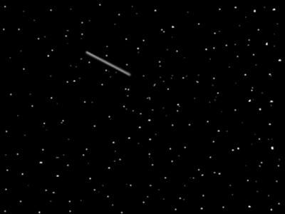
When a photo of a night sky is taken with a (motorized) theodolite, stars are dots and if a satellite is moving during the shot, a line appears on the photo. The idea is to compute the position of the satellite (at the beginning and at the end of the shot) in pixel coordinates and to convert it in Right Ascension and Declination thanks to the position of the stars presents in the photo and a catalogue of thousands of stars. |
Lorsqu'une photo d'un ciel de nuit est prise avec un theodolite (motorisé), les étoiles sont des points, et si un satellite bouge durant la pose de la photo, un ligne apparait. L'idée est de calculer la position du satellite (au début et à la fin de la pose) en coordonnées pixelliques et de les convertir en Ascension Droite et Declinaison grace à la position des étoiles présentes sur la photo et un catalogue de milliers d'étoiles. |